How I Found Every Berlin Postleitzahl Inside the Ring
2026-09-01 · 7 min read · [geospatial] [berlin] [openstreetmap] [data]
I wanted a simple answer: which of Berlin’s postal codes live inside the Ringbahn, the circular S-Bahn loop that rings the center of the city. I expected a five minute Google search. I found no official list, because “inside the ring” is not a legal boundary. Nobody draws it. So I pulled the train’s actual geometry from OpenStreetMap, closed it into a polygon, and measured every postal code against it. Here is the whole method, the map, and every single number.
The short version: There are 185 postal codes in Berlin. I took the S-Bahn ring as a shape (86.8 square km), took each postal code as a shape, and computed how much of each code falls inside the ring. 40 codes sit entirely inside. A further 19 are mostly inside (the ring clips just a corner). 9 straddle the line, and 8 only touch it. So the strict answer is 40; the everyday answer, the one where you still call the place “in the ring,” is 59.
The question, and why it has no official answer
A postal code (Postleitzahl, PLZ) is an administrative region. The city draws its boundaries, but the boundaries are fuzzy: in the map data, neighboring codes do not always meet cleanly, so a thin sliver of map can fall between two of them. The Ringbahn itself is a 37 km loop of track. It is a line, not a wall. A postal code can be cut in two by it.
So “is PLZ X inside the ring” does not have a yes or no answer that any authority will print. It only has a geometric answer: how much of that code’s area lies on the inside of the loop. That is a question a computer can answer, which is why I went looking for the data.
Step 1: Turn the ring into a shape
The Ringbahn runs as the S41 and S42 lines. In OpenStreetMap that is a single route relation (id 14981). A route relation is a list of ways, the individual line segments the train follows. I fetched that list from the Overpass API (a query interface for OpenStreetMap data), chained the segments end to end into one closed loop, and filled it in.
The result is a polygon. It encloses 86.8 square kilometers, which is a sensible number for the area the ring wraps around. That polygon is the “inside the ring” region for everything that follows.
Step 2: Turn every postal code into a shape
OpenStreetMap also maps postal codes as regions, as postal_code boundary relations. I pulled all of them that fall in Berlin’s bounding box. 185 of them are Berlin codes. Each one is a polygon, sometimes several polygons with holes (a code can have an island, or wrap a hole). I reconstructed each code into a proper filled shape the same way: chain the boundary lines, close them, fill.
Step 3: Intersect and score
Now it is plain polygon math. For each of the 185 postal code shapes I compute the overlap with the ring shape, using the Shapely library in Python:
from shapely.geometry import shape
frac_inside = plz_polygon.intersection(ring_polygon).area / plz_polygon.area
That fraction tells me how much of the code is on the inside. 1.0 means the whole code is inside. 0.4 means the ring cuts through it and a bit under half is in. I sort all 185 by that number and split them into four tiers.
The result: four tiers
A. Entirely inside the ring (99.9% or more), 40 codes:
10115, 10117, 10119, 10178, 10179, 10243, 10435, 10555, 10557, 10585, 10587, 10623, 10625, 10627, 10629, 10707, 10717, 10719, 10777, 10779, 10781, 10783, 10785, 10787, 10789, 10823, 10825, 10961, 10963, 10965, 10967, 10969, 10997, 10999, 12043, 12045, 12047, 12049, 12053, 13355
B. Mostly inside, the ring clips a corner (50% to 99.9%), 19 codes:
10245 (54%), 10247 (89%), 10249 (93%), 10405 (99%), 10437 (96%), 10551 (98%), 10553 (70%), 10559 (98%), 10589 (76%), 10709 (98%), 10711 (64%), 10713 (99%), 10715 (97%), 10827 (88%), 12051 (61%), 12055 (57%), 12059 (90%), 12101 (100%), 14059 (65%)
C. Straddles the ring, mostly outside (under 50%), 9 codes:
10407 (29%), 10439 (7%), 10829 (43%), 12099 (23%), 12435 (33%), 13347 (20%), 13353 (14%), 13357 (23%), 14057 (42%)
D. Only touches the ring (5% or less), effectively outside, 8 codes:
10365, 10369, 10409, 12057, 12103, 12159, 14055, 14197
The strict answer is tier A: 40 postal codes. The everyday answer, tier A plus tier B, is 59. Anyone who tells you “I live in the ring” and whose code is in tier B is telling the truth in the way people mean it.
The gaps in the data, and how I filled them
When I first drew this, a third of the ring came out white, colored by no code at all. My first instinct was that the map was wrong, so I checked it against the Berlin postal code map on Wikipedia, which shows the whole city tiled edge to edge with no holes. The reference was right and my data was the problem.

The cause: OpenStreetMap stores each postal code as a set of boundary lines, and those lines do not always meet cleanly. Where two neighboring codes stop short of each other, there is a sliver of map that belongs to no code in the data. Waterways and railway corridors contribute to it too, but the big pieces, like the Tiergarten, are just gaps between boundaries, not areas without a postal code.
So I did what the reference map does: I assigned each gap to the postal code it borders. That removes the white. The map below has no unfilled area inside the ring, and every colored region carries a number.
The map
Green is tier A (entirely inside), yellow is tier B (mostly inside), red is tier C (straddling). The black loop is the S41/S42 ring, and every colored region is labeled with its number.
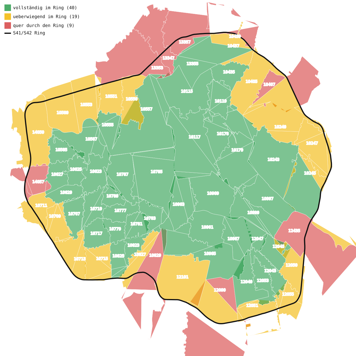
The image is an SVG, so you can zoom into it without losing detail. Open it in a browser and it stays crisp at any size.
Where you would start
This is a small problem, but it has the shape of a lot of “is X inside Y” questions: a fuzzy region, a set of candidate shapes, and a computer that will happily do the measuring. The reusable recipe is:
- Find the region as a geometry. OpenStreetMap has a route relation for the ring and boundary relations for the codes.
- Close each set of line segments into a filled polygon.
- Intersect each candidate with the region and record the fraction of its area that falls inside.
- Sort and tier the fractions.
- Check your coverage. Subtract the union of your polygons from the region, and if you get holes, assign each hole to the shape that borders it.
The hard part is not the code. It is deciding what “inside” means, and accepting that the data will be a little messy at the edges. The numbers above are as good as the underlying map data, and the map data is good enough to be useful.